Case studies
Two diagnoses where the consensus was wrong. The method: find the modifiable lever, refuse the lazy cause.
Not a drought. A vulnerability.
The Panama Canal's water crisis has been misdiagnosed. It is not secular drying or deforestation. It is a system whose margin quietly collapsed.
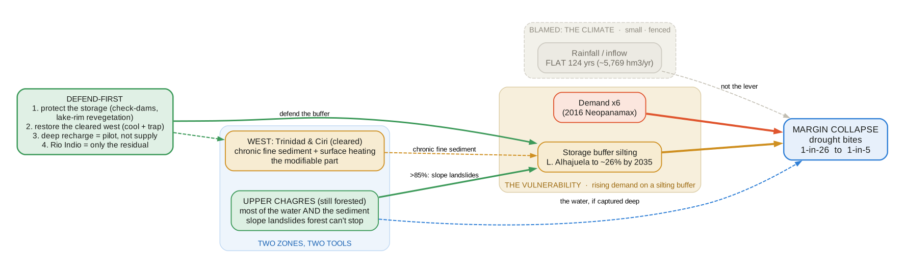
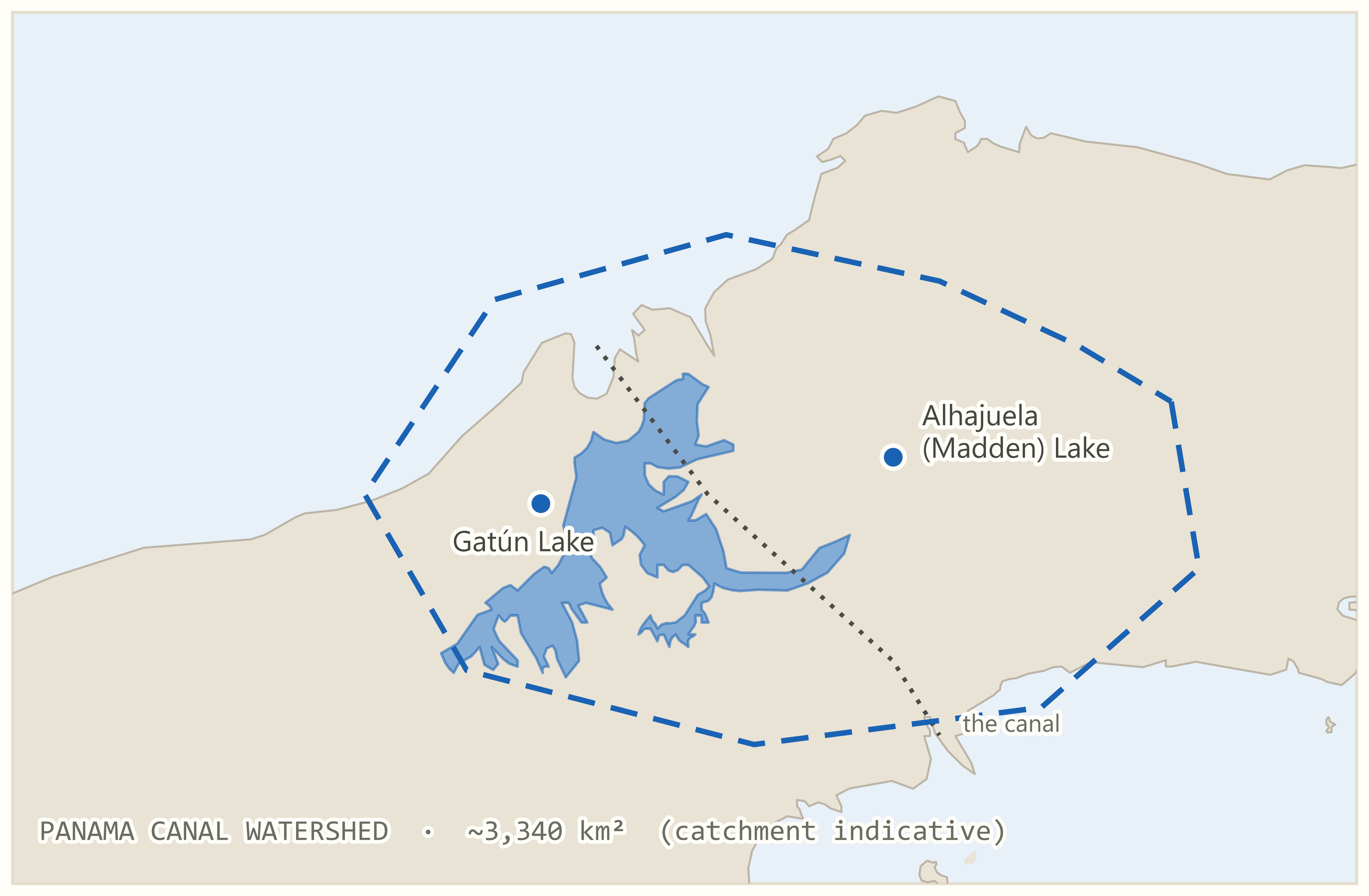
In 2023 and 2024 a dry El Niño year forced the Panama Canal to cut draft and transits, a shock worth on the order of $10 billion to world trade and $500 to $700 million in lost tolls, on a waterway that moves about $270 billion of cargo a year and spends roughly 200 million litres of fresh water on every ship it lifts. But the record kills the obvious explanation: whole-watershed inflow has been flat for 124 years (about 5,769 hm³/yr, no significant trend), so this is not a 'less rain' problem. It is a vulnerability problem. Demand jumped about sixfold with the 2016 Neopanamax expansion, and the storage buffer is being permanently lost as landslide sediment fills Lake Alhajuela toward ~26% of capacity by 2035, so the same ordinary drought that used to bite about once in 26 years now crosses the failure threshold closer to once in 5. And the sediment is not a deforestation story: more than 85% of it comes from slope-driven landslides in intact, steep forest that clearing did not cause and reforestation cannot stop, while cleared land adds a separate, chronic fine-sediment load near the lake. That reframes the fix: you cannot infiltrate your way to a surplus (that math double-counts rainfall already in the balance), so the firm, deficit-scale, national-park-compatible move is to defend the storage you already have, preserving 55 to 146 Mm³ against a roughly 360 Mm³ dry-season deficit, and size any new reservoir like Río Indio (1,250 Mm³, about one once-in-a-century drawdown) to whatever gap remains.
The misdiagnosis
The Canal's water crisis has been misdiagnosed. It is not a story of secular drying or deforestation but of vulnerability. A century of observed record shows the supply essentially flat: mean inflow about 5,769 hm³/yr, with no significant trend in flow, lake level, or dry-season length, and the feeding basins remain 73 to 79 percent forested. So the 2023 to 2024 draft restrictions were an ordinary, episodic El Niño drought hitting a system whose margin had quietly collapsed.
What eroded the margin
Two things eroded that margin, and neither is rainfall. Demand rose roughly sixfold with the 2016 Neopanamax expansion. And the storage buffer is being permanently lost, as landslide-driven sediment fills Lake Alhajuela toward about 26 percent of capacity by 2035. The same drought that once recurred about once in twenty-six years now bites roughly once in five.
Two watersheds, two tools
The watershed is not uniform but two physically distinct zones that demand different tools. The steep, still-forested upper Chagres produces most of the Canal's water and most of its sediment, through slope-and-storm-driven landslides that forest cannot prevent and clearing did not cause; its water must be captured deep and its sediment defended in-channel. The gentle, partly-cleared western Trinidad and Cirí arm carries the modifiable problems, chronic fine-sediment export and surface heating, where revegetation cools and traps sediment but adds little dry-season water.
Defend first
From this the report derives a defend-first recovery program, sized against a roughly 360 Mm³ stressed dry-season deficit and graded by evidence class. Protect the existing storage from sediment before anything else, the one firm, deficit-scale, national-park-compatible lever; then restore the cleared west for cooling and sediment control; treat deep aquifer recharge as a field-gated pilot, not a supply; and build a new reservoir such as Río Indio only to cover the residual the restored watershed cannot, rather than as the reflexive first move.
- ✕It's climate / less rainNo: inflow flat 124 years.
- ✕It's deforestationNo: feeding basins 73–79% forested; >85% of sediment is landslides in intact forest.
- ✕Just infiltrate to a surplusNo: that double-counts rainfall already in the balance.
Not the sky. The land.
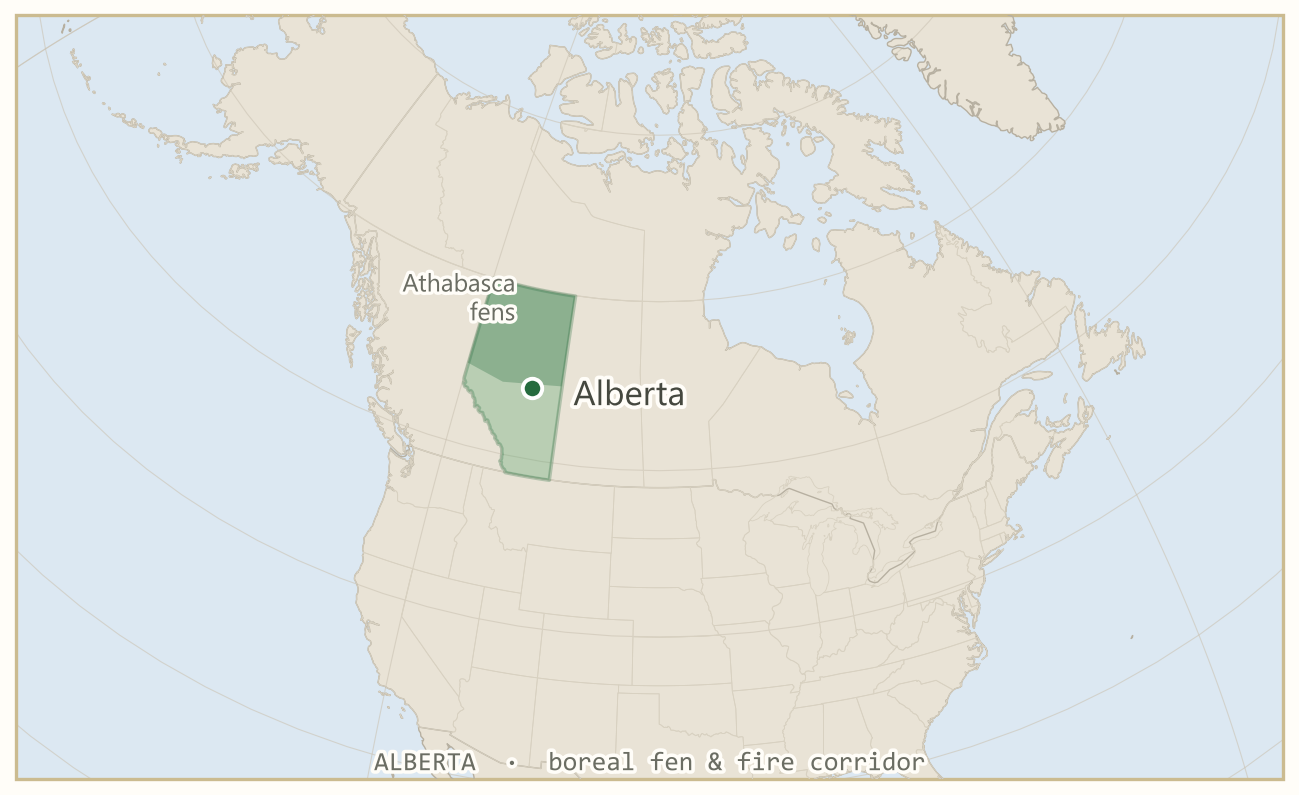
Alberta's failing southern water and its worsening northern fire both get blamed on a changing climate. Read precisely, and often against the original authors' own data, both decompose into something local, mechanical, and reversible.
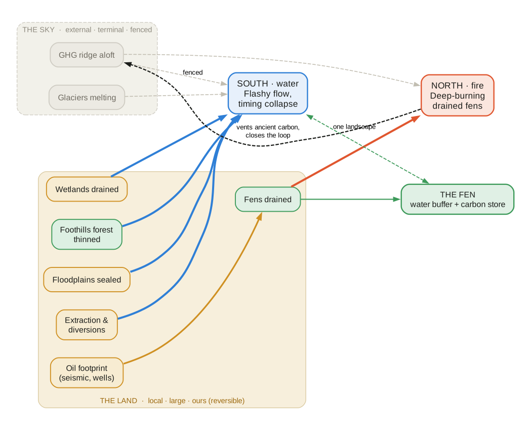
The whole consensus blames the sky, and the sky is real but small and fenced; the water taken, the wetlands drained, the forests thinned, the floodplains sealed and the fens burned are large and local and ours, which is the difference between a warming to endure and a landscape to repair.
The problem
Alberta's water is coming apart at its edges, and its northern forests are burning in larger and smokier years. Late-summer river flow in the settled south is falling. The Southern Saskatchewan basin has been fully allocated and closed to new licences since 2006, with more than seventy percent of the water drawn going to irrigation and only about a fifth of it returning. Two-thirds of the prairie's wetlands are gone. Snow melts earlier each decade. In 2023 the province had a megadrought and a record fire season in the same year. To almost everyone the cause is obvious, and it is the same cause for both: the climate is changing.
The misattribution
That single answer is the thing this report was written to test, because it is largely a misattribution, and it runs on two fronts. On water, the canonical alarm was sounded by David Schindler and Bill Donahue in 2006, in the Proceedings of the National Academy of Sciences: a warming climate had already reduced the western prairies' summer flows, and further warming, through glaciers, snowpack and evaporation, would tighten the crisis. The national climate assessments carried the same frame, and the downscaled model projections behind them. On fire, the parallel consensus is that a hotter world simply burns more. Both are the story the public inherited, and both, read precisely against better data, and often against the original authors' own data, decompose into something local, mechanical and reversible.
Start with the eighty-four percent fall in South Saskatchewan summer flow, the most-cited number in the water alarm. It is real, but it is measured at Saskatoon, downstream of every diversion in the Alberta irrigation belt: it records how much water is taken out, not how much the mountains send down. Read the gauges above the canals, the headwaters themselves, and the summer flow holds. Four years later St. Jacques, Sauchyn and Zhao did the careful version, separating human withdrawal from climate gauge by gauge, and their own table settles it: on the South Saskatchewan at Medicine Hat the naturalized flow, the river with its diversions added back, is rising, while the flow that actually reaches the channel falls. The collapse is in the withdrawal, not the supply. The reported decline in rainfall is in the raw gauge record; the homogenized record, corrected for the way a gauge in wind catches less snow than falls, is flat to slightly wetter. The projected surge in evaporation rests on a temperature-only formula, Thornthwaite's, that the field abandoned decades ago, because evaporation measured directly by an open pan held flat or fell through the warming decades as sun and wind eased. And the crisis itself, in the original, is a model projection, not an observed trend.
The fire consensus gives way the same way. The number that has not risen is the count of dangerous fire-weather days, flat at nine of ten screened stations. What has risen is the Drought Code, the index tied to deep organic and peat-soil dryness, and the readiness of drained and disturbed peat to ignite and burn deep. The drying of the air behind it is thermal: between roughly four-fifths and nearly all of the rise in its drying power is the temperature term, hotter air rather than air stripped of moisture. That warming is external and it is real. But the boreal fire problem is a fuel and ignition problem written on a drained landscape, not a simple verdict that the sky now burns Alberta.
The residual that genuinely belongs to the warming is modest and honest: a weak, non-universal decline of a tenth to two-tenths of a percent a year at a handful of near-natural gauges, consistent with snow arriving as rain rather than a basin running dry. It is a trajectory, not the headline collapse. Only two terms are external and terminal: the greenhouse-forced pressure ridge high in the free atmosphere, and the melting glaciers. Everything else, read this way, is the land. This is why the misattribution matters, and it is not academic. To call the whole thing climate change is to send its cause offshore, to a global carbon budget no province can turn down, and that counsels patience while the water tightens. To locate it correctly, in extraction, drainage, cleared cover and sealed floodplains, is to hand the problem back to the people who can act on it. The misattribution does not merely misname the cause. It removes the agency.
The diagnosis
Underneath, the landscape is a relay of buffers, each holding water for a time before passing it on: canopy, snowpack, glacier, soil, groundwater, stream. A healthy basin is not merely wetter, it is steadier. The buffers have been stripped, so the same water now arrives faster and leaves faster, and the break shows first in timing and distribution, not in totals; a conserved annual mean is the fingerprint of redistribution, not proof of no harm. Trace each broken link and it resolves to management. The dams re-timed the rivers, shaving the freshet and propping the winter. The Foothills headwater forest, the keystone sponge at the top of the chain, has been logged toward the edge between steady and flashy. The prairie wetlands were drained, and draining them removes storage with no safe lower threshold, so the damage begins at the first slough lost. The floodplains and alluvial fans were leveed and built over, which is why the 2013 flood met a landscape that had given away its shock absorbers.
The warming is real and the surface is heating, but how hard that heating bites at the ground is governed by cover. On dry or cleared ground the surface sheds more of its energy as heat than as evaporation, measured directly at flux towers at about one and a half over dry prairie against one over intact fen, so a stripped surface runs hotter and dries the soil faster after each rain. That is a lever, not a verdict: restore the cover and the evaporative cooling returns. What the land cannot do here is change how much rain falls; in this cold, energy-limited, mountain-gated regime the moisture-to-rainfall link that operates in warm, humid climates is switched off, and Alberta's own recycling test found essentially no effect. The break is in energy, partitioning and timing, not in the rainfall total.
The connective gel: fire
The north is not a second problem beside the south. It is the same coupled system at its other end, and fire is what joins them, though not by the arrow one first reaches for. The object that carries the coupling is the peatland fen, which is two buffers in one body: it holds water, which steadies the boreal's late flow and refuses to carry fire, and it holds carbon laid down over millennia, which places it in the climate account as well. Drain the fen, by the seismic lines, roads and well pads that thread the oil-sands country, and it stops being a firebreak and the peat becomes fuel. About four-fifths of the fens in the Athabasca core now lie within a kilometre and a half of that infrastructure, and a drained, burning fen releases on the order of nine times the carbon of an intact one, from a store centuries in the making.
The honest coupling between the two ends is not a wind that carries the south's heat north, tempting as that picture is; the dangerous winds are continental and downslope, and their dryness is the temperature, not moisture stripped from southern fields. The coupling is quieter and harder to escape. One external warming presses on both ends at once, raising the evaporative demand on the southern soil and the drying power of the northern air. One logic of draining and clearing spends the buffers at both ends, wetlands in the south and fens in the north. And the peat closes the loop the others cannot: when it burns it destroys a water buffer that does not return on any horizon a plan can use, closer in that respect to the terminal glacier than to the reversible prairie cover, and it vents its ancient carbon back into the very warming that thins every remaining store, north and south alike. The coupling is not a tidy engineered loop and it is not symmetric, but every turn of it runs one way, toward thinner, and fire is the step that turns a slow drawdown into a fast one.
The repair
Because the crisis is landscape condition and the system is coupled, there is a plan, and it is unusually clean. In the south the leverage runs in order: the Foothills headwater forest first, since it sits at the top of the chain and on the knife-edge, and repairing it propagates downstream on its own, into steadier late-summer flow and a softer landing for the next 2013; then the dams, re-operated for timed, delta-recharging releases; then the prairie wetlands and cover. In the north one control sits over the whole branch, the fen water table, and restoring it loosens three couplings at once: the firebreak returns and ignition and smoke fall, the peat stops oxidising and its carbon stays out of the shared amplifier, and the water buffer holds so the dry season has something to bridge it. One lever, three cuts, made at the other end of one landscape. The supply margin in the committed south is perhaps three to six years from chronic shortfall if demand climbs again, close but not yet fate. Outside the plan sit only the two terminal terms, the ridge aloft and the glaciers it is melting.
- ✕It's less rain / secular dryingNo: whole-basin flow holds above the canals; the homogenized rainfall record is flat to wetter.
- ✕Evaporation is surgingNo: that rests on a temperature-only formula the field abandoned; measured pan evaporation held flat or fell.
- ✕A hotter world just burns moreNo: fire-weather days flat at 9 of 10 stations; the VPD rise is mostly warming. It's drained-peat fuel.
- ✕It's climate, so wait for the carbon budgetNo: it's extraction, drainage, cleared cover and sealed floodplains, local and reversible. That is agency.